
The first river interlinking scheme in India was proposed in the early 1970s, but not pursued seriously due to high expenditure and lack of theoretical basis within the proposals. In 1982 however, an agency - National Water Development Agency (NWDA) was set up, mainly to investigate probable and feasible inter-basin links within the country. The NWDA worked on the conceptual proposal of KL Rao by identification of some basins within the country as ‘surplus’ and others as ‘deficit’. The project proposed to interlink these basins as a solution to the problem of water scarcity within the country. The initial scheme was rejected by the Central Water Commission (CWC), but later a PIL on the NWDA proposal received a Supreme Court order in 2002. The order demanded an expedition of the process of completing the inter-links within a period not exceeding ten years from 2002 onward. More than fifteen years have passed since the judgment, and the first inter-link scheme is set to start its construction now, as of July 2019, in the Ken-Betwa region of Uttar Pradesh and Madhya Pradesh.
This project of interlinking rivers is based on the conceptual framework of arithmetic hydrology, which has often been criticized for asserting itself as a reductionist engineering framework. An exclusive hydrological framework tries to solve concerns of water supply and related hydrological issues through calculable risks and measurements, concerning flows of water. The ecological and socio-political elements involved in the hydrological problems are underplayed. The project, therefore, received mixed responses- from multiple groups, who supported and opposed the plan accordingly. But, this article does not wish to go and explore the reductionist underpinnings within arithmetic hydrology; what it intends to do instead, is to have a holistic understanding of the arguments for and against the proposed project. The article draws on a comprehensive knowledge of ecological elements associated with the plan and tries to assess its effect on fragile ecosystems.
We first have a look at the proposed project and develop an understanding of the basics of inter-basin flows. While intra-linking flows or joining rivers within the same basin happens naturally and is a geo-morphological process; inter-linking of flows from different basins requires building link channels. To link interbasin flows- dams, reservoirs, barrages and several link channels are constructed. As this phenomenon is not a natural consequence, energy is required to pump and allow water to flow into specific channels. The crucial purpose of interlinking rivers across basins is to transfer water, from a basin that is considered to have ‘surplus’ water in hydrological assessments to a basin that is regarded as ‘deficit’.
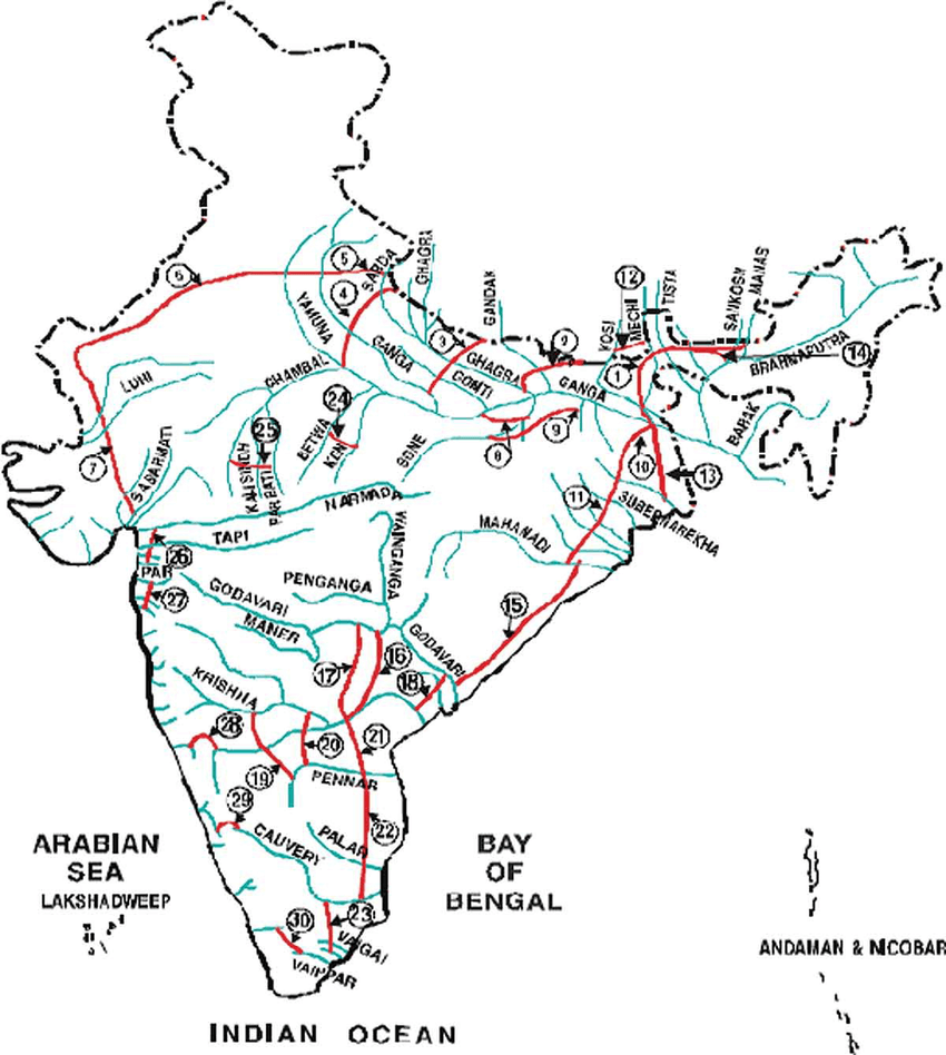
The scope and scale of the proposed project is vast. As depicted in the map above, thirty inter-links have been recommended, connecting flows across different basins within Himalayan and Peninsular India. The significant benefits that the interlinking of rivers offers includes domestic water supply to arid regions, food security, and water supply for irrigation. Additionally, supporters of the proposal have also anticipated sediment control and flood control as a proposed gain.
Then why are there queries being raised over the project? Or why is the proposal facing criticism? The main argument that establishes valid debate against the project comes from estimating the massive cost that the project will be incurring. The cost comes in the form of the direct economic damage incurred, as well as the ecological stress the project is expected to produce in a delicate environment.
India has several ecological hotspots. The areas which include the Western Ghats, the Himalayas, the Gangetic plains, and the Sundarbans are home to numerous species which reside within the unique ecosystems characteristic of these zones. The interlinking project is set to affect all these ecosystems in multiple ways by altering the dynamics of water flows within these areas. It will involve the movement of 245 trillion litres of water through a construction of around 29 canals, and will lead to significant loss of delta areas, which are already on the verge of threat owing to changing climate patterns and flows.
The project, as seen in the above map, is set to alter the amount of discharge from rivers of Eastern India. Besides water sharing with the neighbouring region of Bangladesh, the river discharge in eastern India aids in the maintenance of the largest river delta in the world, the Sundarbans. Rising temperatures have already caused increased sea levels, which pose a threat to the highly fragile delta ecosystem. Ideally, a reduction in the river water discharge will not help, instead add to the vulnerability the area is currently faced with.
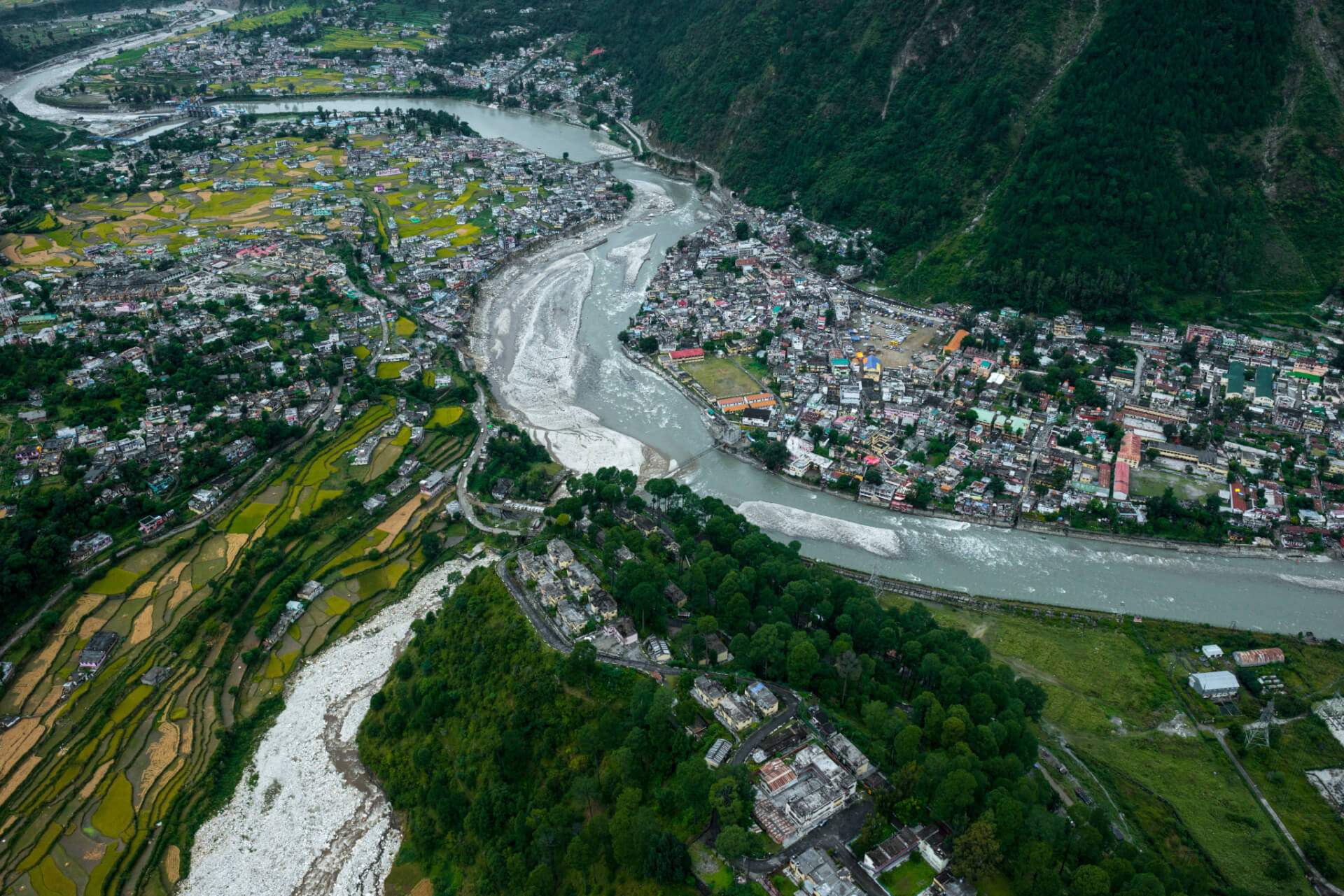
The Himalayan region similarly, is a highly unstable and fragile zone. Himalayas have often been termed as ‘water tower of Asia’, the glaciers there acting as a source of water for many rivers. The geography of the region also makes it prone to natural disasters quite frequently. The past years, owing to increased global temperatures have already seen a rise in incidents of disasters, more so phenomena like slow avalanches. These phenomena, besides damaging life and livelihood, also alter flows within the Himalayan rivers, making them highly predictable.
There also exists a significant knowledge gap in the Himalayan context, which stand as a barrier to the complete and efficient conceptualization of the effects of the inter-links in the area. The reason for the gap is partly unexplored, and partly the steep topography of the region; but it will require a considerably long period to conceptualize the intricacies of the region thoroughly. The Himalayan ecosystem in multiple areas is still vaguely underexplored and conceptualized. Lack of information, especially concerning seismic risks, sediment and floodwater discharge and deposition increases the criticality of the project. Undertaking a massive investment without properly gaining knowledge on the Himalayan waters would not be an ideal step. The Himalayan component is all the more critical owing to the decision of the neighbouring countries and the effect of the construction of large dams which will entail a change in ecosystem affection other nations like Nepal and Bhutan as well.
If we look at Bihar in India, then the estimates for the state, project it as a water surplus region. This is owing to the Gangetic plains of North Bihar which are subjected to recurrent floods every monsoon. The estimates are based on ‘per capita average annual water availability’, which stands at 1061.74 for the entire Gangetic plains stretching from Uttar Pradesh to Bihar.
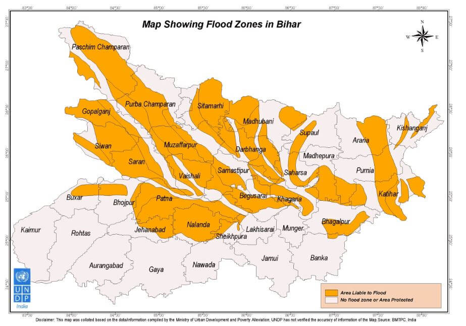
However, a current look at the state of affairs in Bihar presents an interesting and diverse story. There are eighteen out of thirty-eight districts in Bihar which are facing severe drought-like situations; while on the other hand around sixteen areas of the state are hit by floods. Districts like Begusarai, Nalanda and Sheikhpura between June 1 and July 15, have received more than 401 mm of rainfall, which is quite higher than the usual average of 342 mm. These facts suggest that overall estimates for surplus and deficit basins which are based on an average estimation, hardly account for the variations which different regions within the same basin might face simultaneously. The floods in Northern Bihar, occur not solely owing to surplus water in the rivers, they occur due to a combination of factors- ranging from hydro-meteorological to topographical and demographic factors. Sharp gradient changes in the plains and agriculture and other livelihood activities to support the high population density in the area, gives rise to floods.
Quite ironical to the proposed claims, the region of Bihar also has just 30 per cent of its cultivable land under irrigation, while almost 90 per cent of the arable land in the state is irrigable. The rivers in North Bihar- Ghaghra, Gomti and Gandak, after joining Ganga in the Northern part of Bihar, produce non-monsoon flows which are inadequate to meet the demands of India and Bangladesh combined.
A similar story can be seen unfolding in Assam, which is hit by severe floods each year. The Brahmaputra traverses through the North Eastern state of Assam and is flooded every monsoon, drowning certain parts of the state. As of July 22, 2019, almost over 30.55 lakh people in Assam have been affected owing to the floods in the state. As necessary is to ensure the safety of the people during the floods, equally important is to analyze and understand the ecological significance of floodwater. Flood water is a source of free minerals and provides free recharge of groundwater; keeping saline intrusion at bay, floods also help in the formation and maintenance of estuaries. Therefore, draining away floodwater into other basins is not an ideal solution to the problem, rather a holistic idea that looks after the social and economic needs of the displaced people should be sought.
The floods in Assam are also a result of the highly dynamic and unstable nature of the river Brahmaputra. The sediment in the Brahmaputra originates from Tibet, a cold, arid and plantation less region. The sediment is unloaded in parts of Assam when the river loses its velocity. Diverting water from the Brahmaputra to the lower parts (check above map 1, links are proposed to be built from the Brahmaputra to Ganga and Subarnarekha respectively) would adversely affect the dynamics thereby resulting in ecosystem changes in these parts, as already explained above concerning the context of Sundarbans.
Drainage of floodwater also reduces the amount of sediment and water drained into the ocean. The Brahmaputra discharges around 19, 830 cumec water into the ocean, making it the fourth-largest river in the world in the form of discharge into the sea. Drastically reducing the discharge into the ocean has its own drawbacks, witnessed in the Aral sea, a freshwater lake which has been shrinking in its size and capacity to support aquatic life, mainly owing to reduced discharge from its water sources. Reduced discharge, as mentioned earlier, would affect the estuarine ecosystem, thereby curtailing necessary forms of livelihood that have been developed around these areas.
While evaluating the claims the project has in terms of an arrangement to help the domestic water needs or the food security of the country, one tends to come up with more cons than pros of the project. If we lay our eyes on the domestic water needs of cities in India, then the needs of the people are adjusted by supply, and not by demand in all urban areas in India. In India, the per capita consumption of water in most cities is far below the standards prescribed by the Bureau of Indian Standards. Within cities, there exists a massive difference in areas, concerning the housing arrangement and income standards; slum areas suffer the most. Almost 72 per cent of households with monthly income below INR 3000 severely water-deprived. The domestic water needs form a small portion of the total water demand of an area; however, it is quite a significant issue.
The inter-linking project, however, seems to solve little problems, as the approach remains the same- collecting water at a common point far away from the supply point and distribution through long canals. If the cost of the water supplied through the inter-linking scheme is compared to the cost of localized initiatives like rainwater harvesting to allow domestic water supply, then the later is much lower- in terms of economic costs as well as water loss during supply. Considering the ill-effects nationalization and privatization of water has had on the supply of domestic water, another scheme that further links up major river basins of the country is not a welcome policy. Furthermore, extreme drought-prone areas situated on higher parts of river basins will remain disconnected and hence would not be able to reap benefits from the project.
Food security in India, with the vast population of the country, is undoubtedly a pressing issue. However, low food productivity in India caused not mainly due to the unavailability of water. India has explicitly extremely low food grain productivity per unit volume of water, which suggests that there is no ‘efficient’ utilization of the available water, or non-food crops are given preference over food grains in agriculture. Therefore the additional 173 bcm of water that the inter-linking project is proposing to provide for India’s food security will not materialize to yield desired results if the water use efficiency remains low or in a state of absence of any legal control over its use.
However, the people who have acclaimed and supported the project propose arguments highlighting the plight of the subaltern in drought-hit regions of India. Radha Singh in a paper has argued, how inter-linking is intended to solve the water crisis in the country by evenly distributing water within the 51 million hectares of drought-prone and 40 million hectares of flood-prone region. Pointing out increasing rates of distress migration from drought and flood-prone areas, a claim is made that suggests, 265 million people in India who live below the poverty line, threatened by water linked adversity, would benefit immensely from the interlinking scheme. The claims of the natural geography being altered owing to the construction of interlink and resulting transfers have been countered by citing examples of Canada, France, Australia and Germany among others.
Canada has completed 37 inter-linking projects, allowing the transfer of 268 bcm water annually, the USA also has a rate of transferring 34 bcm water annually. As much one might start believing in the capacity of the inter-linking project to solve the water-woes of the entire nation, we need to justify the validity of these claims in the Indian context. The socio-economic variations, political and geographical nature of India and its rivers are very different from that of the countries it has been compared to. The domestic water allocation and availability in India are affected, by not just the physical scarcity of water, but also by the shortage constructed from an interlinked network of social and economic class differences.
The political elements within the arguments are vast and need to be explored separately, but even a superficial exploration suggests that the sharing of water within different Indian states has not been a pleasant experience in the past. The water sharing between Tamil Nadu and Karnataka is a classic example. After several rounds of discussions and appeals by both the states, the crisis has continued for over fifty years now; the water of the river Cauvery is now allocated based on Supreme Court order of 2018 to both the states. The Cauvery Water Management Authority oversees water management in the area, but sharing of water has created political bitterness in relationships between both neighbouring states and has clearly not helped much in solving the water woes of Tamil Nadu.
The interlinking project has a prospect of leading to differences between the neighbouring nations of Bangladesh and Nepal as well. Bangladesh, specifically as a nation that receives water downstream of the rivers, will be affected with reduced flows.
On reviewing the arguments for and against the project, one can conclude that the project is set to develop a series of linkages that connect inter-basin rivers. In this article, I have left out the discussion the project will have in terms of displacement of people and wildlife, considering many inter-basin construction and changes in river flows are associated with it. A review not encompassing these essential drawbacks also highlights the inherent flaws in the planning of the project- which has happened mainly considering hydrological assessments and not over-all eco-sociological cost-benefit analysis. A project that involves such high economic and ecological stakes needs a holictic evaluation in the absence of which such a gigantic project- which is claimed to be the largest waterworks construction in terms of finances, should not be carried forward.
Image Credits: National geographic
References
Ahmad, I. (2012). Teesta, Tipaimukh and River Linking: Danger to Bangladesh-India Relations. Economic and Political Weekly , 51-53.
Bandyopadhyay, J., & Perveen, S. (2004). Interlinking of Rivers in India: Assessing the Justifications. Economic and Political Weekly , 5307-5316.
Khalid, M. A. (2004). The Interlinking of Rivers Project in India and International Water Law: An overview. Chinese JIL , 553-570.
Kishore, R. (2016, April 27). India is the biggest virtual exporter of water. Retrieved July 22, 2019, from Livemiint: https://www.livemint.com/Opinion/bPPHFHv19qBaA5qrPa6SuN/India-is-the-biggest-virtual-exporter-of-water.html
Rao, M. M. (2018, September 04). The impact of the river linking project. Retrieved July 22, 2019, from The Hindu: https://www.thehindu.com/opinion/op-ed/the-impact-of-the-river-linking-project/article24857371.ece
Singh, R. (2003). Interlinking of Rivers. Economic and Political Weekly , 1885-1886.
Transfer, I. o.-B. (2004). Prasad, T. Economic and Political Weekly , 1220-1226.
Vaidyanathan, A. (2003). Interlinking of Peninsular Rivers: A Critique. Economic and Political Weekly .